(via TheNewswire)
 |
|||||||||
-
Westside Area of the Tombstone project, adjacent to the historic Contention open pit, continues to show mineralized features with high potential for shallow gold-silver expansion drill targets
-
Contention Pit area field work and sampling is providing key information to delineate and expand the wide mineralized zone on surface and is being integrated into a 3D model for the first time
Vancouver, Canada – May 22, 2024 – TheNewswire – Aztec Minerals Corp. (AZT: TSX-V, OTCQB: AZZTF) (“Aztec” or the “Company“) announces that 3D modeling of gold-silver mineralized features supports a high confidence interpretation for continuity of shallow, oxidized Au-Ag exploration and drilling targets, below, alongside and to the West of the Contention Open pit at the Tombstone Project in Southeastern Arizona. The ongoing review and modelling of extensive historic and current data, combined with ongoing field work at the Tombstone Project has provided the key elements to building the first 3D model of the historic Tombstone Silver District, incorporating: underground workings, mined stopes, geology, multielement geochemistry, SWIR alterations, and geophysics. The modelling’s preliminary results show the basis of the primary geological controls of gold-silver mineralization down to over 300 meters depth. This is an important milestone to support exploration drilling of shallow targets to potentially extend the footprint of the known gold-silver mineralized zones.
Surface exploration confirms much of the upper portions of the historic data and strengthens the confidence of the 3D model. The surface exploration and modelling have also exposed areas of potential Au-Ag mineralization not extensively explored in the past. The ability to integrate historic and current exploration data for the first time in 3D at the Tombstone Project provides Aztec with valuable information and a strong foundation to continue expanding the footprint of the shallow gold-silver mineralization.
The Tombstone JV owns patented claims related to the Contention and Westside mines. Both mines host the three main deposit styles in the Tombstone district (fissure stringer vein lodes, mineralized Qfp dikes with breccias, and CRD mineralized beds in anticlines). They both encompass multiple, historic mines that produced high-grade gold-silver oxide mineralization at the Tombstone Project.
Recent review of historic data and on-site investigations by Aztec have confirmed that the Westside area was previously planned as an expansion of the Contention pit operations at the time on the interruption of mine operations in 1982. This review identified the Westside area as a high potential target for shallow gold-silver mineralization, almost doubling the project’s potential gold-silver oxide mineralization footprint near to the historic Contention Pit (please see news release dated April 22, 2024).
Aztec has completed a wire frame model of the tunnels (see Figure 1 below) and the Quartz-feldspar dikes (Qfp) (see Figure 2 below), which acted as mineralized solution conduits in the historic Tombstone Silver district. Aztec is now modelling the mined stopes, such as those of the Westside anticline (see Figure 3 below) and then model the intricate folded and faulted sedimentary geology.
Figure 1- Tombstone Project – Initial stage of the 3D modelling is of wire framed underground workings of the Westside Area and Contention Pit Areas
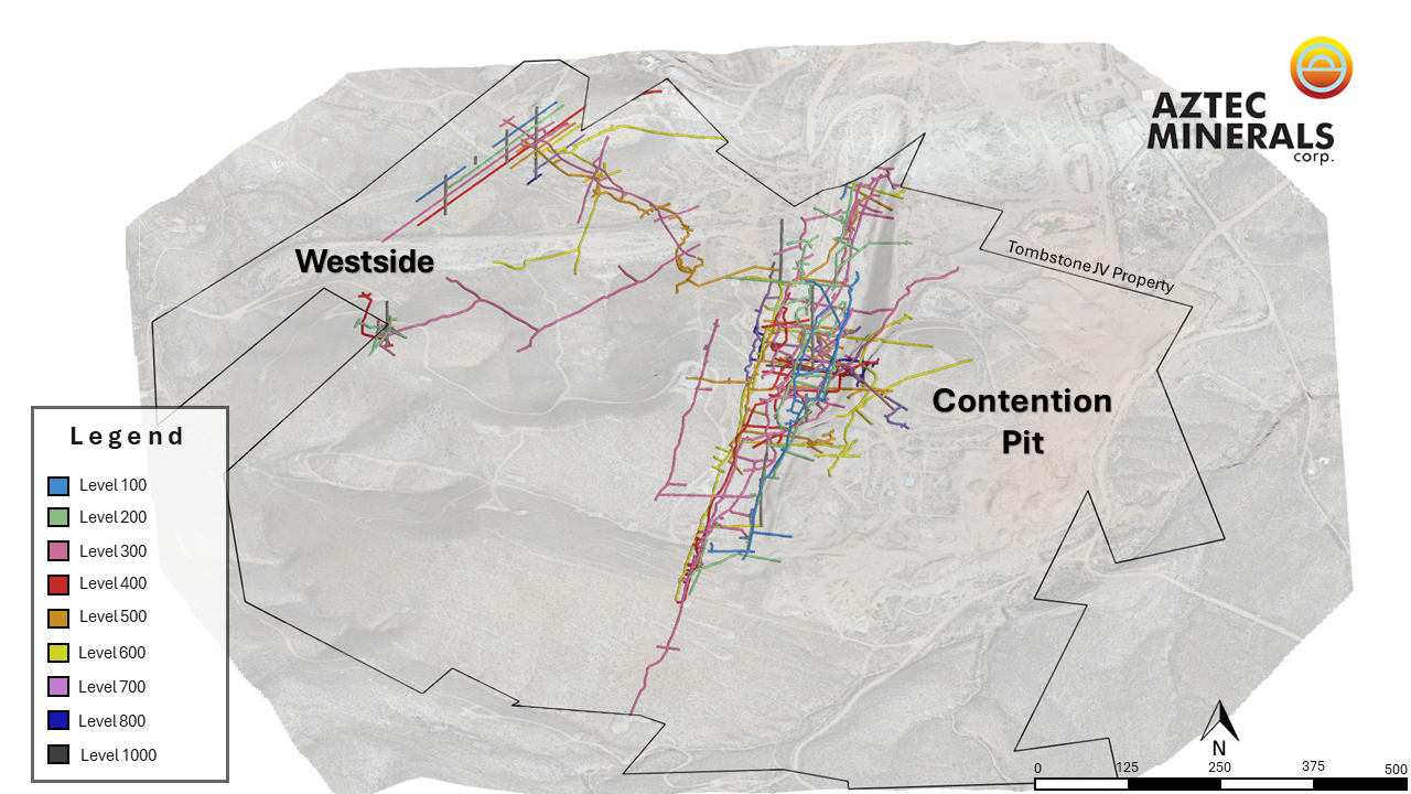
Click Image To View Full Size
Aztec’s recent surface exploration has confirmed the presence of several known and new mineralized features and mine workings and has georeferenced their positions in the project area. This has confirmed the historic positions of the underground workings and related important mineralized features, and that the mineralized features could be exploration targets, with evidence that their intersection potentially hosts broad gold-silver mineralization near surface.
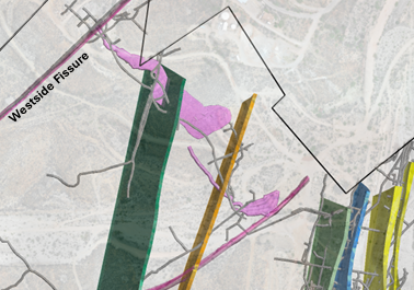
Review of historic data has confirmed the Westside anticline was mined on at least five separate, stacked, oxidized CRD replaced layers in the sediments near the crest of the axis along its 450+ m length, noting that, at its intersection with the Arizona Queen Fissure at the fifth level (see Fig. 3 below), the 120 m long Sulphuret stope, was mapped at over 60 m wide and 10-20 m thick. The Sulphuret stope was reported (Butler, 1938) to have production averaging 70 opt silver with high-grade gold. Aztec drilling has confirmed that the gold-silver mineralization in the property extends beyond the limits of the historically mined stopes.
Figure 2. Tombstone Project Qfp Dikes with Property Limits Plan View
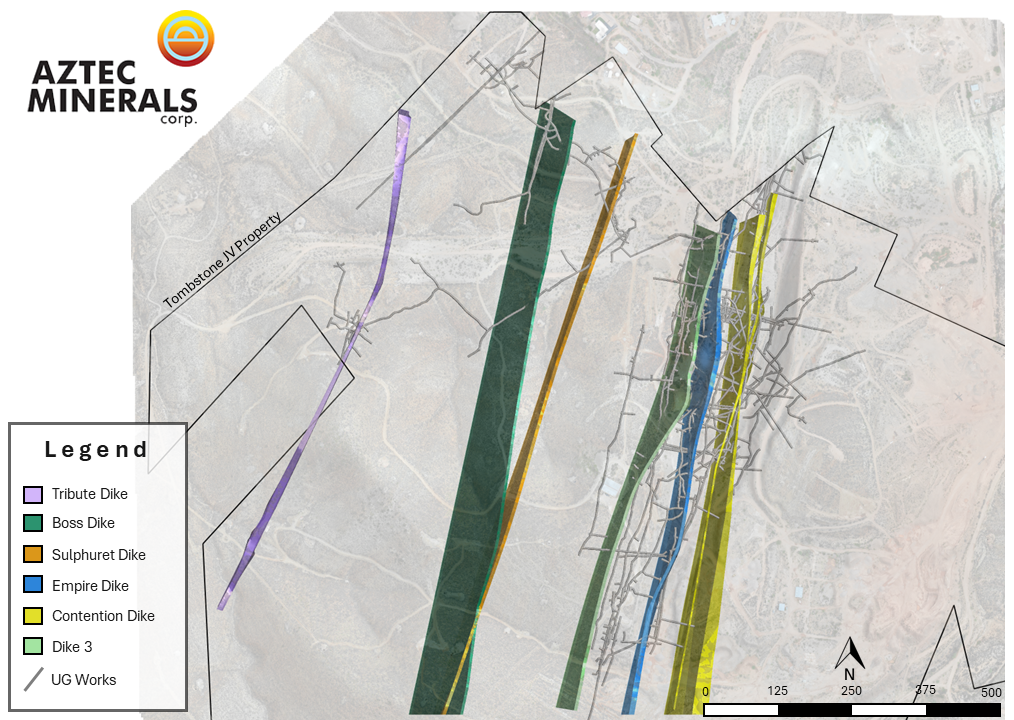
Click Image To View Full Size
Most of the Westside area and its multiple targets have yet to be explored, representing a key area for future drilling and potential shallow resource delineation. The Westside – Sulphuret mine workings reached to the 7th and 8th levels (210-250 m), and historic drilling has significant CRD-style mineralized intercepts at 500 to 600 m depths. Several poorly explored anticlines, with evidence of mineralization at the edge of the historic open pit, have been identified and will be part of the exploration targeting.
In the Tombstone district the sedimentary hosted mineralization (CRD) is focused on the anticlines, in multiple, stacked horizons that have favorable permeability and chemistry with associated skarning-hornfelzing, argillic and silicic alterations. It appears the Qfp dikes generally have significant Au-Ag mineralization associated with them in the sedimentary country rock at an estimated average radius of 15 meters distally from their physical limits. The dikes and the quartz stringer lode-fissures at their intersections with the favorable sedimentary horizons often develop broad zones of mineralization.
Figure 3. Detail of the Westside Anticline, Fifth Level Stopes (Fuchsia colour) with Westside and Arizona Queen Fissure Lodes (Magenta color), mineralized Qfp dikes and mine workings
Current Exploration Program
Aztec’s crews onsite are continuing the 2024 Tombstone exploration program (see news release dated April 22, 2024). Company is currently developing high priority drill targets as a result of the surface exploration program in the area of the Contention pit and surroundings, advancing the detailed geological mapping, and further out with reconnaissance level geological mapping of lithologies, Terraspec SWIR alterations and structures, multi-element rock geochemistry, and thin section petrology and alterations to review the hosting of the gold-silver mineralization. The data acquired is being integrated into the 3D model being constructed including the historic mine workings and geologic mapping of the principal portion of the Tombstone district. The 3D model is being geolocated to the current surface and geology, geochemistry and geophysics and will then be interpreted to strengthen both shallow and deep drilling targeting. This information will be used in supporting the upcoming drilling program design.
The ongoing exploration program is adding key knowledge into the expansion potential of the bulk tonnage, gold-silver oxidized mineralization, and from that, continue drilling and mineralization footprint. The focus of this exploration program is to better define the three styles of mineralization known to exist on the property and to identify top priority targets for drilling. The three types of known mineralization at the Tombstone property are as follows:
-
Silver-gold bearing, north-northeast striking felsic intrusive dikes hosting mesothermal stock-works and hydrothermal breccias that cut the Cretaceous Bisbee Group and the underlying Paleozoic carbonates, on which the historic Contention underground mine and later the 1980’s open pit heap leach mine was developed, which now is known to extend laterally and vertically beyond the Contention pit
-
High-grade, silver-gold quartz stringer vein lodes striking northeast cutting the Cretaceous Bisbee Group clastic sediments and the Paleozoics, which are related to several of the historic mines in the Tombstone district
-
Tombstone’s well known, high grade, oxidized, silver-gold rich base metal carbonate replacement deposits (“CRD”), which lie in the lowermost Bisbee Group and in the underlying Paleozoic carbonates, have a geologic setting very similar to the world-class Hermosa Taylor base metal sulfide deposit of South32, located 65 kilometers southwest of Tombstone. Strong structural controls of the Tombstone CRD deposit locations related parallel to the crests of anticlines, usually with vertical (“reef”) stacking on multiple, favorable horizons
Positive indications for mineralization at Tombstone include:
-
The Bisbee sediments exhibit widespread fracturing, silica-pyrites-sericite-clay alteration, quartz veinlets, stockworks, and hornfelsing and in the limestones jasperoids, dolomitization and skarn development
-
The Contention open pit mine is centered along a strong NNE fault structure with large, mineralized felsic dikes possibly related to a deeper intrusion
-
The underground Contention mine mined the dike mineralization to over 300 m depth
-
Historic drilling by Newmont and Santa Fe to over 700 m depth have intersected narrow to wide, high grade CRD mantos, evidence that the Paleozoic limestones are prospective
-
The presence of several manganese-silver rich mines surround the Property are considered indicative of distal mineralization to CRD deposits worldwide
Tombstone Project Overview
Aztec holds a 75% interest in the Tombstone Property Joint Venture, which includes most of the original patented mining claims in the main district as well as some recently acquired properties.
The main target of the 2023 core drill program was to continue testing the shallow, bulk tonnage, heap leachable, mesothermal gold-silver oxide mineralization adjacent and below the previously mined Contention pit by infill and step-out drilling. Core drilling was deemed necessary to penetrate the multiple historic workings and to acquire needed geological data. Future drilling is expected to focus on strike and dip extensions of the shallow oxide mineralization and move deeper to test for larger and deeper “Taylor-type” CRD targets along and adjacent to the Contention structure.
The Tombstone project is located 100 kilometers (km) southeast of Tucson, Arizona and covers much of the historic Tombstone silver district. Tombstone is renowned for its high grade, oxidized, silver-gold mesothermal stringer lode veins, hydrothermal breccias and manto CRD orebodies that were mined in the late 1800’s and early 1900’s. The historic silver production in the Tombstone district from 1878 to 1939 was estimated at 32 million ounces and 250,000 ounces of gold.
The district geology consists of a mix of shallow-level, oxidized Au-Ag and base metal deposits related to CRD and skarns hosted in folded and thrusted sediments, intrusive dikes and lode veins, and as well the under explored, sulfide versions located below the water table.
Host rocks to the mineralization are primarily the clastic sediments of the lowest portion of the Cretaceous Bisbee Formation. Between 50 and 300 meters (m) in depth, the Bisbee is underlain by approximately two kms thick of the same Paleozoic carbonate formations that host the 110 MT Hermosa-Taylor zinc-lead-silver deposit of South32 located 60 km southwest of Tombstone.
Although the historic silver mines at Tombstone were generally small, Aztec believes they could be related to much larger mesothermal and CRD orebodies below the old mines. Since 2017, Aztec has completed geological mapping, geochemical sampling and geophysical surveying to identify the most prospective areas for Au-Ag mineralization around and below the Contention open pit, and CRD zinc-lead-copper-silver-gold mineralization below the entire district. Aztec management views the district as highly prospective for the discovery of mesothermal and CRD orebodies.
Note: Gold equivalents are calculated using a 80:1 silver:gold ratio in 2020 and 2023 and a 70:1 silver:gold ratio in 2021. Reported lengths are apparent widths, not true widths. The Contention Au-Ag mineralization zones are generally west dipping at around 60-80 degrees, associated with the quartz-feldspar porphyry dikes. However, these dikes also extend as sills in shallow angles out from the Contention fault along fold noses in the Bisbee clastic sediments so the full range of mineralization dips vary from 20 to 80 degrees. True widths for the apparent mineralization intersection widths of the drill holes approximately range from 50 to 100% of the apparent widths, with the norm for the mineralized true widths being 60 to 90% of the apparent widths. Please see summary news releases dated: July 5, 2023, December 7, 2021, and January 12, 2021.
*Grade-Thickness in meters-grams/tonne means the result of multiplying a drill hole intercept length, measured in meters, by the grade of the gold values in the intercept, the resulting compiled number is measured in grams/tonne. Grade thickness is not to be construed as gross metal value nor as a resource. The Tombstone property does not have a current, compliant resource estimation at this point.
Summary Tombstone Project Highlights
-
Well located property on patented (33) and unpatented (42) claims (452.02 hectares/1,116.94 acres), covers much of the historic Tombstone silver mining district, great infrastructure, local town, road access, full services, water, power
-
Historic silver district produced 32 million oz silver from 1878-1939, in high grade, oxidized, silver-gold-lead-zinc-copper vein, breccia and CRD deposits, and small open pit heap leach production in late 1980’s
-
Drilling by Aztec in 2020-23 has demonstrated that the Contention Pit target has significant, shallow. oxidized Au-Ag bulk tonnage mineralization which is open in all directions
-
Multiple other prospective targets in Cretaceous and Paleozoic rocks related to major NW and NNE trending structures hosting porphyritic intrusions crosscutting a possible caldera ring structure
The following are highlights of recent drilling intersections supporting the conceptual exploration model for mineralized footprint growth.
-
TR21-22: 2.44 gpt Au and 66.56 gpt Ag (3.39 gpt AuEq)over 65.5m (including 16.80 gpt Au and 374.36 gpt Ag over 7.6m)
-
TR21-03 – 5.71 gpt Au and 40.54 gpt Ag (6.28 gpt AuEq) over 32.0m
-
TC 23-01: 3,477 gpt Ag over 1.52m from a zone of 733.9 gpt Ag over 7.6 m within 125 m of 1.63 gpt AuEq
-
TR21-10: 1.39 gpt Au and 56.40 gpt Ag (2.20 gpt AuEq) over 96.0m
-
TR21-13: 1.8 gpt Au and 36.9 gpt Ag (2.33 gpt AuEq) over 70.1 m
-
TR21-17: 1.73 gpt Au and 56.20 gpt Ag (2.53 gpt AuEq) over 64.0m
-
TR21-08: 2.09 gpt Au and 47.1 gpt Ag (2.76 gpt AuEq) over 39.6m
-
Hole TC23-02 – 1.69 gpt gold and 29.07 gpt silver (2.03 gpt gold AuEq) over 45.3 m, including 10.1 m grading 6.63 gpt gold and 72.81 gpt silver (7.49 AuEq)
-
TC23-05 – 2.816 gpt gold and 176.64 gpt silver (5.02 gpt AuEq) over 36.0 m, including 6.45 gpt gold and 408.47 gpt silver (11.554 gpt AuEq) over 15.5 m
The company in conjunction with its exploration sampling programs uses quality assurance-quality control as part of its sampling-assaying-assessments. Samples and their collection are controlled by an industry standard conforming QAQC program including insertions of certified standards, blanks and sample duplicates. The samples are being regularly shipped to and received by the Bureau Veritas Minerals laboratory in Hermosillo, Mexico for geochemical analysis.
Core and RC drilling samples are continuously collected over 5 foot (1.52m) sample intervals from all drill holes. The samples were analyzed for gold with a 30-gram sample size using the fire assay method FA430 followed by multi-element MA300, including silver. Over limits, when present, are analyzed by MA370 or FA530. All holes contain certified blanks, standards, and duplicates as part of the quality control program.
Allen David Heyl, B.Sc., CPG., VP Exploration of Aztec, is the Qualified Person under NI43-101, supervised the Tombstone exploration programs. Mr. Heyl has reviewed and approved the technical disclosures in this news release.
“Simon Dyakowski”
Simon Dyakowski, Chief Executive Officer
Aztec Minerals Corp.
About Aztec Minerals – Aztec is a mineral exploration company focused on two emerging discoveries in North America. The Cervantes project is an emerging porphyry gold-copper discovery in Sonora, Mexico. The Tombstone project is an emerging gold-silver discovery with high grade CRD silver-lead-zinc potential in southern Arizona. Aztec’s shares trade on the TSX-V stock exchange (symbol AZT) and on the OTCQB (symbol AZZTF).
Contact Information – For more information, please contact:
Simon Dyakowski, President & CEO, Director
Tel: (604) 685-9770
Fax: (604) 685-9744
Email: [email protected]
Website: www.aztecminerals.com
Neither the TSXV nor its Regulation Services Provider (as that term is defined in the policies of the TSXV) accepts responsibility for the adequacy or accuracy of this release. No stock exchange, securities commission or other regulatory authority has approved or disapproved the information contained herein.
Forward-Looking Statements:
This news release contains “forward?looking information or statements” within the meaning of applicable securities laws, which may include, without limitation, completing ongoing and planned work, develop new drill targets at the Tombstone project, carrying out future exploration work on the Company’s projects, other statements relating to the technical, financial and business prospects of the Company, its projects and other matters. All statements in this news release, other than statements of historical facts, that address events or developments that the Company expects to occur, are forward-looking statements. Although the Company believes the expectations expressed in such forward-looking statements are based on reasonable assumptions, such statements are not guarantees of future performance and actual results may differ materially from those in the forward-looking statements. Such statements and information are based on numerous assumptions regarding present and future business strategies and the environment in which the Company will operate in the future, including the price of metals, the ability to achieve its goals, that general business and economic conditions will not change in a material adverse manner, that financing will be available if and when needed and on reasonable terms. Such forward-looking information reflects the Company’s views with respect to future events and is subject to risks, uncertainties and assumptions, including the risks and uncertainties relating to the interpretation of exploration results, risks related to the inherent uncertainty of exploration and cost estimates and the potential for unexpected costs and expenses, and those filed under the Company’s profile on SEDAR+ at www.sedarplus.ca. Factors that could cause actual results to differ materially from those in forward looking statements include, but are not limited to, continued availability of capital and financing and general economic, market or business conditions, adverse weather or climate conditions, failure to maintain or obtain all necessary government permits, approvals and authorizations, failure to obtain or maintain community acceptance (including First Nations), decrease in the price of gold, silver and other metals, increase in costs, litigation, and failure of counterparties to perform their contractual obligations. The Company does not undertake to update forward?looking statements or forward?looking information, except as required by law.
Copyright (c) 2024 TheNewswire – All rights reserved.
COMTEX_452750747/2895/2024-05-22T15:10:26
Disclaimer: The views, suggestions, and opinions expressed here are the sole responsibility of the experts. No News Feed Central journalist was involved in the writing and production of this article.